NAVIGATION
Resilient Navigation and Timing Foundation
in Washington DC. The group lobbies the
government to protect, toughen and
augment GPS. Defense IT supplier Harris
Corporation is a member.
Loran was originally developed as a
navigation system during World War 2. By
the end of the conflict it covered 30% of the
earth’s surface and eventually covered 70%.
The last Loran C system, a more accurate
version than the original, was
decommissioned in the US in 2010.
The US Transportation Department’s
Volpe Center did a study on the vulnerability
of GPS in 2001 which stated that an
improved Loran C system might provide a
backup to GPS for positioning and timing,
but that more study was needed. Later the
government decommissioned Loran C, but
the idea of Loran as a backup has been batted
around in Washington government circles
ever since. The question of whether a system
will actually be built remains to be seen,
although there has been some positive action
towards the development of a GPS-backup
politically in the USA.
GPS is a critical timing source for
computer networks and the US financial
system. Parkinson says some advocates for
eLoran are trying to sell the idea of building
a system based on its value as a timing
backup alone. However, eLoran can only
provide timing backup at the microsecond
(one millionth of a second) level, which is
sufficient for computer and financial
network synchronization but not for the
nanosecond (one billionth of a second)
timing that scientific users need and already
receive from GPS.
Alternative backup
But does civil aviation need eLoran? There is
already an array of ground based navaids
available that could guide an airline aircraft
to a safe landing in the case of a widespread
(Image: UrsaNav)
GPS outage. The FAA sees DME/DME
(Distance Measuring Equipment) area
navigation (RNAV) and ILS (Instrumented
Landing Systems) as suitable backups for
airline aircraft air navigation and VOR (Very
High Frequency (VHF) Omni-Directional
Range) for other aircraft. The FAA’s NextGen
program is adding 130 new DMEs to
improve coverage and resiliency in the event
of a GPS outage. This program is expected to
be completed by 2033.
But spectrum pressure may also pose a
threat to aviation’s use of DME in the future,
Berz notes. International Mobile
Telecommunications providers maintain
aviation is wasting valuable spectrum by
using DME in the L band because it is a
high-frequency sweet spot in terms of its
range and ability to carry large amounts of
data. “A lot of radio services would like to
have this part of the spectrum because it is
prime real estate,” he says. “At some time in
the future pressure could increase to provide
mobile broadband to rural communities and
governments could decide this is a high
Left: The baseline GPS constellation consists of 24 satellites
positioned in six earth-centered orbital planes
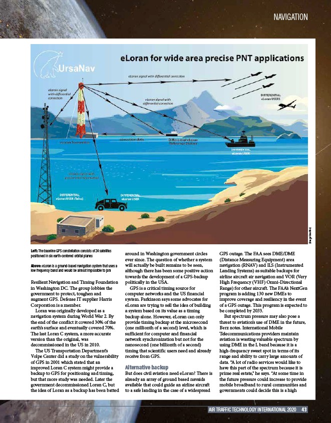
Above: eLoran is a ground-based navigation system that uses a
low frequency band and would be almost impossible to jam
AIR TRAFFIC TECHNOLOGY INTERNATIONAL 2020 43.